Jun 9, 2020
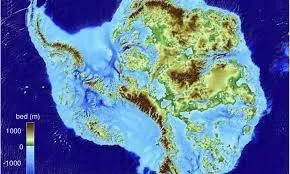
Image: BedMachine image of Antarctica - Mathieu Morlighem / UCI/phys.org
In a laboratory in southern California, a researcher is poring over data from deep beneath the Earth according to magellantimes.comT. Collected thousands of miles away in Antarctica, the measurements reveal a startling picture of a little-known world. But on a planet that’s changing fast, they could also hold a vital clue to the perils of climate change.
Ever since the explorer James Cook first navigated this frozen wasteland, mankind has been fascinated by the vast expanse of Antarctica. But while modern technology has helped us to map its frozen terrain, there is much about this mysterious continent that remains unexplained. And considering it’s almost twice the size of Australia, that’s probably no big surprise.
But beginning in 2014, a team of researchers from multiple institutions have been using a combination of physics and tech to create a new map of Antarctica. And five years later, they released the startling results. As well as a striking discovery, they’ve learned more about the impact of climate change in one of Earth’s most extreme regions.
As global temperatures rise, many are concerned about what will happen if Antarctica’s ice sheet melts. And in order to predict the future, scientists must gather as much information as they can about the frozen continent. But will this latest development help us to stave off a terrifying fate?
The least-visited continent on planet Earth, Antarctica remains a mystery to much of the world. In fact, its 5.5 million square miles are not home to any permanent residents. And only a handful of researchers and tourists visit every year. But for all its desolation, the frozen region holds an almost hypnotic sway that has captured our imagination.
Located in the far southern hemisphere surrounding the South Pole, Antarctica is almost completely covered in ice. And in many places, these frozen shelves stretch down for more than 6,200 feet. Unsurprisingly, this hostile environment is difficult for humans to survive in, although animals such as seals make it their homes.
With no indigenous population, Antarctica didn’t become known until the 1770s, when the British navigator Cook began exploring the region. And since then, researchers have made several attempts to uncover the secrets of the frozen continent. But with temperatures that have been known to reach almost -130°F, collecting data here is no easy task.
In the past, researchers have used radar technology in order to map the terrain that lies beneath the ice sheets of Antarctica. Using pulses of microwave radiation, they have been able to gaze beneath the frozen tundra and build up a picture. However, this technique has always had its limitations.
For example, in some of the deepest parts of Antarctica, radar technology has been unable to accurately map the terrain. According to experts, this is because the microwaves bounce off the sides of valleys or trenches without reaching the bottom. And as such, it has been impossible for them to determine exactly what lies beneath the surface.
However, in December 2019 all that changed thanks to a team of researchers from various institutions across Europe, Australia, China, South Korea, India and the United States. You see, that month the results of a study led by the University of California were published. And contained within it were some fascinating new facts about Antarctica.
Dubbed BedMachine Antarctica, the project set out to build the most accurate map yet of the terrain beneath the frozen continent. And in order to do so, they consulted records from 19 different institutions dating all the way back to 1967. In the decades since, it seems, researchers have compiled almost a million miles worth of radar data.
Using this data as a starting point, the researchers began building their map of Antarctica. However, there were still large areas of the continent that remained uncharted. So they turned to a different approach in order to fill in the gaps – a method known as mass conservation.
Using this data as a starting point, the researchers began building their map of Antarctica. However, there were still large areas of the continent that remained uncharted. So they turned to a different approach in order to fill in the gaps – a method known as mass conservation.
Essentially, the principle of mass conservation is a law in physics which advances that mass cannot change over time. Therefore, in a system where neither matter nor energy can enter or leave, the mass will remain the same. And even if chemical reactions take place within that system, the resultant components will have the same mass.
But what does that mean in layman’s terms? And how has it helped the researchers behind the BedMachine project build up a clearer picture of the Antarctic terrain? Well, by following the principle of mass conservation, it seems, the team could establish just how much ice is trapped in the continent’s sunken valleys. So let’s look into this more closely.
Apparently, the process involved using satellite data to determine exactly how ice was moving across Antarctica. And once researchers knew how much frozen matter was entering the continent’s valleys – and how quickly it was moving – they had everything they needed. Armed with this information, they were well on their way to filling in the gaps left by the microwaves.
Yes, and by establishing the volume of ice in Antarctica’s valleys, the researchers could learn even more. Apparently, they were also able to determine how deep the features stretched beneath the surface. And not only that, it seems, they could even predict the shape and contours of the valley floor.
So on December 12, 2019, the results of the study were finally made public in the scientific journal Nature Geoscience. And the following day, they were announced at the Fall Meeting of the American Geophysical Union in San Francisco, CA. Amazingly, the researchers had succeeded in creating the most detailed map of Antarctica to date.
This is undoubtedly the most accurate portrait yet of what lies beneath Antarctica’s ice sheet,” study co-author Dr. Mathieu Morlighem told the BBC in December 2019. But even he could not have predicted what this ground-breaking work would uncover. According to reports, it seems, BedMachine has revealed a record-breaking canyon hidden beneath the surface.
In East Antarctica, where the frozen continent meets the Southern Ocean, there is an Australian territory known as Queen Mary Land. And back in 1912, explorers discovered a vast glacier in this remote and desolate terrain. Dubbed the Denman Glacier, it stretches for some 12 miles across the landscape.
However, the really exciting thing about the Denman Glacier is the canyon that lies beneath it. And thanks to the BedMachine project, we now know that this valley reaches far below sea level – some 11,500 feet to be exact. In fact, it’s the deepest point ever discovered on the surface of the Earth.
Before this discovery, the deepest known point on land was located thousands of miles away on the edge of the Dead Sea. But at only 1,355 feet below sea level, this is nothing compared to the canyon beneath the Denman Glacier. In fact, the measurements place the new find some eight times deeper than the previous record holder.
Of course, the new discovery is far from the deepest point on planet Earth as a whole. In fact, the famous Mariana Trench in the Pacific Ocean plunges to almost seven miles down. That’s almost 37,000 feet. But back on dry land, however, the canyon mapped by Morlighem and his colleagues is definitely a record holder.
And while some have pointed out that there are valleys on land that could give Antarctica’s a run for their money, such as China’s Yarlung Tsangpo Grand Canyon, the comparison seems unjust. According to records, the latter reaches a depth of almost 20,000 feet, making it undoubtedly a record-breaker in its own right. However, unlike the terrain beneath the Denman Glacier, its floor is not below sea level.
The trenches in the ocean are deeper, but this is the deepest canyon on land,” Morlighem told the BBC. However, until the BedMachine project came along, previous efforts to map the valley had been unsuccessful. “There have been many attempts to sound the bed of Denman, but every time they flew over the canyon – they couldn’t see it in the radar data,” the researcher continued.
The trough is so entrenched that you get side-echoes from the walls of the valley and they make it impossible to detect the reflection from the actual bed of the glacier,” Morlighem explained. But now, researchers have been able to catch a glimpse of the canyon in all its glory.
Thanks to this discovery alone, the BedMachine project has earned its place in the history books. However, Morlighem and his colleagues found more than just the deepest point on the surface of the Earth. In fact, their achievements may help to pave the way for a deeper understanding of how climate change will affect our planet. So let’s find out more.
Interestingly, it’s all to do with how this previously unmapped terrain could affect the retreat of Antarctica’s glaciers as the Earth heats up. According to researchers, landscapes that slope inland can actually speed up this process, causing rising sea levels. However, it’s not all bad news, and apparently there are certain geographical features that can have the opposite effect.
At the Transantarctic Mountains, for example, a number of glaciers have formed on the eastern coast of the frozen continent. And at the moment, they flow into the Ross Sea, where a floating sheet of ice stems their flow. Previously, however, some researchers have expressed concern over what might happen should that sheet melt.
According to previous models, it was predicted that the ice sheet melting would speed up the rate at which the glaciers feed into the Ross Sea. However, the BedMachine project has revealed data that could challenge this preconception. Apparently, the study has discovered that a high ridge runs beneath the ice.
Crucially, this ridge could slow down the rate at which the glaciers of the Transantarctic Mountains drain into the sea. And as such, the melting of the Ross Sea ice shelf might not be quite as catastrophic as some had previously feared. In fact, Morlighem notes, the hypothetical scenario of a faster retreat could be a false alarm.
If something happened to the Ross Sea ice shelf – and right now it’s fine, but if something happened – it will most likely not trigger the collapse of East Antarctica through these ‘gates,’” Morlighem told the BBC. “If East Antarctica is threatened, it’s not from the Ross Sea.” Sadly however, the outlook was not quite so hopeful elsewhere.
For on the other side of Antarctica, a vast glacier approximately the size of the United Kingdom flows into the Amundsen Sea. And already, it’s one of the region’s fastest-moving shelves of ice, traveling more than a mile every year. But according to the data compiled by the BedMachine project, it could retreat even faster in the future.
Crucially, the study has revealed that the Thwaites Glacier, as it is known, sits on top of a landscape that slopes inland. And according to experts, this type of terrain typically speeds up retreat. But unfortunately, that’s not all. According to researchers, the land beneath the glacier is almost completely devoid of the sort of ridges that might slow it down.
In fact, according to the study, there are just two ridges in the land surrounding Thwaites Glacier. And these are between 18 and 30 miles away from its current location. So once the retreating ice has passed these points, there could be no stopping it. Given the vast size of the glacier, experts have noted, this could be a cause for concern.
But while it might be difficult to imagine how this lost world beneath Antarctica affects the glaciers above, one researcher has provided an excellent analogy. According to Dr. Emma Smith, who worked with Morlighem, the process is similar to how a thick liquid moves across a surface.
Imagine if you poured a bunch of treacle on to a flat surface and watched how it flowed outward,” Smith told the BBC. “Then pour the same treacle on to a surface with a lot of lumps and bumps, different slopes and ridges – the way the treacle would spread out would be very different.” And according to the researcher, the ice in Antarctica behaves in the exact same way.
Interestingly, the Thwaites Glacier and the Transantarctic Mountains were not the only regions to be exposed by the BedMachine project. According to reports, researchers also learned more about the terrain beneath Recovery Glacier in northwest Antarctica. At some 60 miles long, the vast ice sheet currently sheds some 35 billion tons of ice and water every year.
However, thanks to BedMachine, researchers have been able to learn more about the terrain beneath Recovery Glacier. Apparently, the bed is crisscrossed by trenches that could be hundreds of feet deeper than previously believed. And with this clearer picture of what Antarctica looks like underneath, we may be able to improve our predictions for the future.
Moving forwards, the team plan to use the information gathered by BedMachine to update existing models of how Antarctica might respond to climate change. And with better data, it’s hoped we can build a better understanding of how the continent might change as temperatures rise.
For many, this work is seen as vital if we are to survive the perils of climate change. In the last 18 years, experts claim, as much as three trillion tons of ice has vanished from Antarctica. And if the planet continues to get warmer, this trend will likely continue, seeing sea levels rise across the globe. But while we may not be able to halt this terrifying process, we might at least begin to understand it. And with understanding come new solutions, hopefully, to the problem.
Share this article with friends!
Tags:
#anartic#ice,#history,#starzpsychicnetwork,#starzpsychics,#staz#advisors