Jun 7, 2016
In an easy to understand article by Jeffrey Masters, Ph.D. — Director of Meteorology, Weather Underground, Inc. we learn about the Gulf of Mexico and its importance in the weather cycle.
The Loop Current is an ocean current that transports warm Caribbean water through the Yucatan Channel between Cuba and Mexico. The current flows northward into the Gulf of Mexico, then loops southeastward just south of the Florida Keys (where it is called the Florida Current), and then just west of the westernmost Bahamas. Here, the waters of the Loop Current flow northward along the U.S. coast and become the Gulf Stream. With current speeds of about 0.8 m/s, the Loop Current is one of the fastest currents in the Atlantic Ocean. The current is about 200 - 300 km (125 - 190 miles) wide, and 800 meters (2600 feet) deep, and is present in the Gulf of Mexico about 95% of the time. During summer and fall, the Loop Current provides a deep (80 - 150 meter) layer of vary warm water that can provide a huge energy source for any lucky hurricanes that might cross over.
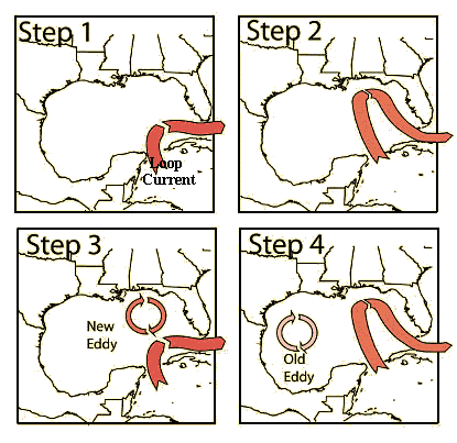 Figure 1. The Loop Current flow northwards into the Gulf of Mexico. Every 6-11 months, a bulge in the current cuts off into a clockwise-rotating eddy that then drifts slowly west-southwestward towards Texas. Image credit: NOAA.
The Loop Current commonly bulges out in the northern Gulf of Mexico and sometimes will shed a clockwise rotating ring of warm water that separates from the main current (Figure 1). This ring of warm water slowly drifts west-southwestward towards Texas or Mexico at about 3-5 km per day. This feature is called a "Loop Current Ring", "Loop Current Eddy", or "Warm Core Ring", and can provide a key source of energy to fuel rapid intensification of hurricanes that cross the Gulf, in addition to the Loop Current itself. The Loop Current pulsates in a quasi-regular fashion and sheds rings every 6 to 11 months. When a Loop Current Eddy breaks off in the Gulf of Mexico at the height of hurricane season, it can lead to a dangerous situation where a vast reservoir of energy is available to any hurricane that might cross over. This occurred in 2005, when a Loop Current Eddy separated in July, just before Hurricane Katrina passed over and "bombed" into a Category 5 hurricane. The eddy remained in the Gulf and slowly drifted westward during September. Hurricane Rita passed over the same Loop Current Eddy three weeks after Katrina, and also explosively deepened to a Category 5 storm.
So, a key question each hurricane season is: when will the next Loop Current Eddy break off, creating a ready-made high-octane energy source for any hurricane that might pass by? A good way to answer this question is to study the behavior of the Loop Current over the past year. This can be viewed at Navy Research Lab's web site, including a large movie (51 Mb) of the past year's currents. This movie has arrows showing the direction of the current, plus a color coding that represents the height of the sea surface above mean level. The higher the height, the warmer the water (since warm water expands and thus raises the sea level where it is at).
We've also saved a copy of this animation covering the period October 2005-October 2006. One can see at the beginning of the animation the Loop Current Eddy that fueled Katrina and Rita sitting in the Gulf of Mexico south of Louisiana. This eddy moves slowly west-southwest to a point off the Texas coast by November, where it gradually dissipates. A small Loop Current Eddy breaks off eight months later in March, and a large one just four months later, in July. The July 2006 eddy gets temporarily re-absorbed in September, then breaks free again by October.
The Navy web site offers a 1-month forecast of the Loop Current in the Gulf of Mexico. However, according to an interesting February 2004 article published by offshore-engineer.com, reliable forecasts of these currents and eddies are not available yet. Keep in mind that currents are driven by winds, and wind forecasts are not reliable out more than about 10 days.
For more information: A 1998 paper published in the Journal of Physical Ocenaography titled, Loop Current Eddy Paths in the Western Gulf of Mexico provides some technical information on Loop Eddies. Horizon Marine, Inc. tracks and forecasts Loop Eddies and provides a pay service for this. Louisiana State University has a nice series of images showing the passages of Ivan, Katrina and Rita over Loop Current Eddies.
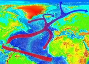
Image: Evolution of the Gulf Stream to the west of Ireland continuing as the North Atlantic Current - Wikipedia
Share this article with friends!
Tags:
#meteorology,#weather#underground,#loop#current,#Yucatan#Channel,#gulf#of#mexico,starzpsychics.com,#starz#advisors,#wikipedia