Sep 9, 2017
Image: Weather forecaster - clipartpanda.com
According to this article from earthobservatory.nasa.gov we find that weather forecasting isn't a relatively new invention.
Imagine a rotating sphere that is 12,800 kilometers (8000 miles) in diameter, has a bumpy surface, is surrounded by a 40-kilometer-deep mixture of different gases whose concentrations vary both spatially and over time, and is heated, along with its surrounding gases, by a nuclear reactor 150 million kilometers (93 million miles) away. Imagine also that this sphere is revolving around the nuclear reactor and that some locations are heated more during one part of the revolution and other locations are heated during another part of the revolution. And imagine that this mixture of gases continually receives inputs from the surface below, generally calmly but sometimes through violent and highly localized injections. Then, imagine that after watching the gaseous mixture, you are expected to predict its state at one location on the sphere one, two, or more days into the future. This is essentially the task encountered day by day by a weather forecaster (Ryan, Bulletin of the American Meteorological Society,1982).
Early History
The art of weather forecasting began with early civilizations using reoccurring astronomical and meteorological events to help them monitor seasonal changes in the weather. Around 650 B.C., the Babylonians tried to predict short-term weather changes based on the appearance of clouds and optical phenomena such as haloes. By 300 B.C., Chinese astronomers had developed a calendar that divided the year into 24 festivals, each festival associated with a different type of weather.
Around 340 B.C., the Greek philosopher Aristotle wrote Meteorologica, a philosophical treatise that included theories about the formation of rain, clouds, hail, wind, thunder, lightning, and hurricanes. In addition, topics such as astronomy, geography, and chemistry were also addressed. Aristotle made some remarkably acute observations concerning the weather, along with some significant errors, and his four-volume text was considered by many to be the authority on weather theory for almost 2000 years. Although many of Aristotle’s claims were erroneous, it was not until about the 17th century that many of his ideas were overthrown.
Throughout the centuries, attempts have been made to produce forecasts based on weather lore and personal observations. However, by the end of the Renaissance, it had become increasingly evident that the speculations of the natural philosophers were inadequate and that greater knowledge was necessary to further our understanding of the atmosphere. In order to do this, instruments were needed to measure the properties of the atmosphere, such as moisture, temperature, and pressure. The first known design in western civilization for a hygrometer, an instrument to measure the humidity of air, was described by Nicholas Cusa (c.1401-1464, German) in the mid-fifteenth century. Galileo Galilei (1564-1642, Italian) invented an early thermometer in 1592 or shortly thereafter; and Evangelista Torricelli (1608-1647, Italian) invented the barometer for measuring atmospheric pressure in 1643.
While these meteorological instruments were being refined during the seventeenth through nineteenth centuries, other related observational, theoretical, and technological developments also contributed to our knowledge of the atmosphere; and individuals at scattered locations began to make and record atmospheric measurements. The invention of the telegraph and the emergence of telegraph networks in the mid-nineteenth century allowed the routine transmission of weather observations to and from observers and compilers. Using these data, crude weather maps were drawn and surface wind patterns and storm systems could be identified and studied. Weather-observing stations began appearing all across the globe, eventually spawning the birth of synoptic weather forecasting, based on the compilation and analysis of many observations taken simultaneously over a wide area, in the 1860s.
sounding plot
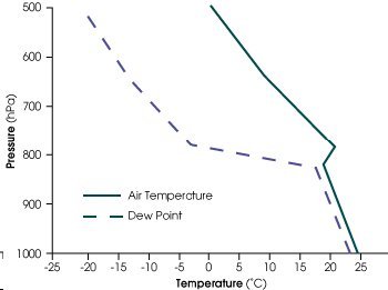 A schematic sounding of air temperature and dewpoint derived from radiosonde data. This sample schematic sounding includes a temperature "inversion" (temperatures increasing with height) at about 800 hPa and reflects atmospheric conditions that frequently precede the development of severe thunderstorms and possibly tornadoes. [1 hectoPascal (hPa) = 1 millibar (mb).] (Courtesy of NOAA.)
With the formation of regional and global meteorological observation networks in the nineteenth and twentieth centuries, more data were becoming available for observation-based weather forecasting. A great stride in monitoring weather at high altitudes was made in the 1920s with the invention of the radiosonde. Small lightweight boxes equipped with weather instruments and a radio transmitter, radiosondes are carried high into the atmosphere by a hydrogen or helium-filled balloon that ascends to an altitude of about 30 kilometers before bursting. During the ascent, these instruments transmit temperature, moisture, and pressure data (called soundings) back to a ground station. There, the data are processed and made available for constructing weather maps or insertion into computer models for weather prediction. Today, radiosondes are launched every 12 hours from hundreds of ground stations all over the world.
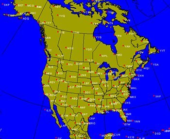 The North American network of upper air ground stations, each indicated by a three-letter station identifier. Radiosondes are launched and tracked from each location every twelve hours. (Courtesy of NOAA.)
Towards Numerical Prediction
Over the past few centuries, physical laws governing aspects of the atmosphere have been expressed and refined through mathematical equations. The idea of numerical weather forecasting—predicting the weather by solving mathematical equations—was formulated in 1904 by Vilhelm Bjerknes (1862-1951, Norwegian) and developed by British mathematician Lewis Fry Richardson (1881-1953, British). Despite the advances made by Richardson, it took him, working alone, several months to produce a wildly inaccurate six-hour forecast for an area near Munich, Germany. In fact, some of the changes predicted in Richardson’s forecast could never occur under any known terrestrial conditions. Adding to the failure of this effort, a six-hour forecast is not particularly useful if it takes weeks to produce.
Courageously, Richardson reported his results in his book Weather Prediction by Numerical Process, published in 1922. In one of the chapters of this work, Richardson describes a scheme for predicting the weather before it actually happens, a scheme involving a roomful of people, each computing separate sections of the equations, and a system for transmitting the results as needed from one part of the room to another. Unfortunately, Richardson’s estimated number of human calculators needed to keep pace with weather developments was 64,000, all located in one very large room.
Richardson’s work highlighted the obvious fact that a large number of calculations had to be made very rapidly in order to produce a timely forecast. In the late 1940s, using one of the earliest modern computers, significant progress toward more practical numerical weather forecasts was made by a team of meteorologists and mathematicians at the Institute for Advanced Study (IAS) in Princeton, New Jersey. Mathematician John von Neumann (1903-1957, Hungarian-American) directed the construction of the computer and put together a team of scientists led by Jule Charney (1917-1981, American) to apply the computer to weather forecasting. Charney determined that the impracticality of Richardson’s methods could be overcome by using the new computers and a revised set of equations, filtering out sound and gravity waves in order to simplify the calculations and focus on the phenomena of most importance to predicting the evolution of continent-scale weather systems. In April 1950, Charney’s group made a series of successful 24-hour forecasts over North America, and by the mid-1950s, numerical forecasts were being made on a regular basis.
Modern Tools of the Trade
Modern technology, particularly computers and weather satellites, and the availability of data provided by coordinated meteorological observing networks, has resulted in enormous improvements in the accuracy of weather forecasting. Satellites, in particular, have given forecasters routine access to observations and data from remote areas of the globe. On April 1, 1960, the polar-orbiting satellite TIROS 1 (the first in the series of Television and Infrared Observation Satellites) was launched. Although the spacecraft operated for only 78 days, meteorologists worldwide were ecstatic over the pictures of the Earth and its cloud cover that TIROS relayed back to the ground.
 The first picture of Earth from a weather satellite, taken by the TIROS-1 satellite on April 1, 1960. Although primitive in comparison with the images we now receive from satellites, this first picture was a major advance.
Over the past 40 years, satellite sensor technology has advanced enormously. In addition to providing visual images, satellites can also provide data that allow calculation of atmospheric temperature and moisture profiles and other environmental variables. This is done using a variety of instruments, among them atmospheric sounders, which measure quantities at various levels in atmospheric columns. The data retrieved from sounder measurements taken from a satellite can be made similar to radiosonde observations, with the major advantage that the satellite data are more complete spatially, filling in gaps between weather ground stations, which often are hundreds or even thousands of kilometers apart.
 Full-disk GOES-8 water vapor image from September 5, 1995. (Courtesy of NASA.)
The Aqua Spacecraft
In 2002, the Atmospheric Infrared Sounder (AIRS), the Advanced Microwave Sounding Unit (AMSU), and the Humidity Sounder for Brazil (HSB) will be launched together on NASA’s Earth Observing System (EOS) Aqua satellite, a satellite that will also carry a Moderate Resolution Imaging Spectroradiometer (MODIS), two Clouds and the Earth’s Radiant Energy System (CERES) sensors, and an Advanced Microwave Scanning Radiometer for EOS (AMSR-E). The AIRS/AMSU/HSB sounding system will provide the capability for determining atmospheric temperature and moisture more accurately than ever before from space-based measurements. These measurements will be provided to the National Oceanic and Atmospheric Administration (NOAA), the European Centre for Medium-Range Weather Forecasts (ECMWF), and the weather community at large for assimilation into operational numerical weather prediction models. It is expected that assimilation of global AIRS/AMSU/HSB data, complementing other operational observations, should lead to a substantial improvement in the accuracy of mid- and long-range weather forecasts.
 The Aqua spacecraft, with pointers to the AMSU-A1, AMSU-A2, AIRS, and HSB instruments. - NOAA
The AIRS/AMSU/HSB instrument suite builds on the technical heritage of NOAA’s High Resolution Infrared Sounder (HIRS) and Microwave Sounding Unit (MSU). The HIRS/MSU combination was the National Weather Service’s (NWS’s) operational weather sounding system for nearly twenty years, flying on numerous NOAA polar orbiting satellites. This system was enhanced in the late 1990s by the replacement of the four-channel MSU by a 20-channel AMSU, which includes Aqua’s AMSU and HSB channels. Looking toward further improvements in weather forecasts, the NWS has set measurement requirements for temperature at an accuracy of 1°C in layers 1 km thick and humidity at an accuracy of 20% in layers 2 km thick in the troposphere (the lower part of the atmosphere, where weather systems are of most relevance to human life and property). AIRS/AMSU/HSB will meet these requirements, allowing meteorologists to improve and extend their predictions and reduce the number of significant prediction mistakes, like failing to predict a major storm prior to a few hours before its arrival.
Benefits to Society
The potential economic benefits of more accurate weather forecasts are immense. For example, a more accurate 24-hour forecast of heavy rain and thunderstorms along a cold front could allow airline dispatchers enough time to reroute their airplanes appropriately and thereby help alleviate costly delays. Being able to pinpoint a wintertime low temperature in Florida could be the deciding factor in whether orange grove farmers make the correct decision regarding deployment or non-deployment of freeze prevention methods to save their crops. Better information on wind patterns could aid the National Hurricane Center in producing a more accurate forecast of a hurricane’s track and might enable a reasoned decision to be made regarding evacuating thousands of families out of Miami or Jacksonville. In military operations, there is a considerable historical record of instances when weather conditions have altered the course of battles, including examples when accurate forecasting has been a deciding factor in one side’s victory.
Closing
Only fifty years ago, weather forecasting was an art, derived from the inspired interpretation of data from a loose array of land-based observing stations, balloons, and aircraft. Since then it has evolved substantially, based on an array of satellite and other observations and sophisticated computer models simulating the atmosphere and sometimes additional elements of the Earth’s climate system. All this has been made possible by advances in satellite technology, a sweeping acceleration in worldwide communications, and overwhelming increases in computing power. Aqua’s AIRS/AMSU/HSB combination should further these advances, enabling more accurate predictions over longer periods.
https://earthobservatory.nasa.gov/wxforecasting
Share this article with friends!
Tags:
#weather,#forecaster,#starzpsychics.com,#starz#advisors